
Belltopper Gold Project Mineral Resource
| HIGHLIGHTS |
- An Inferred Mineral Resource of 760,000 tonnes at 3.6 g/t Au for 87,000 oz contained gold is reported for the Leven Star Reef within the Belltopper Gold Project.
- The Leven Star Reef is relatively shallowly drilled (44 holes in total) and mineralisation remains open in multiple directions; providing a number of opportunities for resource growth.
- The Leven Star Reef Mineral Resource has been assessed on the basis of underground mining only.
- The Leven Star Reef represents one of eight high-grade gold-bearing reefs that comprise a recently upgraded Exploration Target at Belltopper Gold Project1. The remaining seven reefs comprising the Exploration Target provide a robust opportunity for additional resource growth at Belltopper from multiple sources to complement the Leven Star Resource.
- Other known prospective historic gold reefs at the Belltopper Gold Project not currently within the Exploration Target also remain underexplored and provide near-term opportunity to grow the Exploration Target .
- Planning is advanced for drilling in H2 2026 to further define the current Exploration Target Reefs and test additional known historic reefs.
- High-priority, drill ready targets within the important “Belltopper Anticline Corridor,” will also be tested as part of the upcoming drilling program.
The 2026 Inferred Mineral Resource Estimate with an effective date of 9 June 2026 for the Belltopper Gold Project Leven Star Reef is provided in Table 1.
Table 1. Inferred Mineral Resources for the Belltopper Gold Project Leven Star Reef.
| Classification | Cut-off grade (g/t Au) | Tonnes (t) | Grade (g/t Au) | Troy ounces (Au) |
| Inferred Mineral Resource | 1.9 | 760,000 | 3.6 | 87,000 |
The optimized MSO stope shapes were estimated with the following indicative parameters:
- Gold price: A$5,250/oz gold.
- Bulk density applied: oxide mineralisation 2.50 t/m3 (waste 2.35 t/m3), transitional mineralisation 2.60 t/m3 (waste 2.45 t/m3) and fresh mineralisation 2.65 t/m3 (waste 2.70 t/m3).
- AU$162/t mining cost and AU$119/t processing cost (including G&A and surface haulage).
- Metallurgical recovery at 88%.
- Mining is based on sub-level open stoping with 15 m level to level separation, mining recovery of 90%, minimum mining width at 1.5 m and 0.2 m HW and FW dilution.
- Victorian State Royalty of 2.75% and discount factor 8%.
- A period of between 5 to 10 years is considered appropriate for “eventual economic extraction” for the LSR, noting that gold price operating expenditure, and regulatory conditions may change during the period.
- It is assumed that mineralisation would be fed to a process plant within reasonable haulage distance.
Underground resource reported diluted within Mineable Shape Optimisations (MSOs) generated above a gold cut-off grade of 1.9 g/t Au.
PERTH, Australia, June 08, 2026 (GLOBE NEWSWIRE) -- Novo Resources Corp. (Novo or the Company) (ASX: NVO) (TSX: NVO) (OTCQB: NSRPF) is pleased to report a Mineral Resource classified as an Inferred Mineral Resource in accordance with the JORC Code (2012) for the Leven Star Reef at its 100% owned Belltopper Gold Project (‘Belltopper’) in Victoria. The Leven Star Reef represents one of eight reefs that comprise the Exploration Target at Belltopper reported on 11 February 2026.
Belltopper is located 120 km northwest of Melbourne and approximately 60 km south of Agnico Eagle’s (TSX: AEM) Fosterville Gold Mine (Figure 1) in the Bendigo Zone, an area with historical gold production of more than 60 million ounces2.
Kaiser Reef Limited’s (ASX: KAU) Maldon processing plant is located some 40 km to the northwest of the project area and Alkane Resources Limited’s (ASX: ALK) Costerfield’s operation is located some 50 km to the northeast of Belltopper.
Mineral Resource classification was generally allocated according to estimation pass, and considered data type, quality and distribution, and bulk density measurement availability. Reasonable Prospects for Eventual Economic Extraction (RPEEE) have been determined by evaluation within Datamine MSO shapes. Estimates have been verified by visual review, examination of swath plots, volume-to-tonnage comparisons, and sensitivity analysis.
The terms ‘Mineral Resource’, ‘Inferred Mineral Resource’, ‘Indicated Mineral Resource’, ‘Ore Reserves’ and ‘Feasibility Study’ have the meanings as given in the JORC Code (2012). Mineral Resources are not Ore Reserves and do not have demonstrated economic viability; it is uncertain if applying economic modifying factors will convert Measured and Indicated Mineral Resources to Ore Reserves. The estimate of Mineral Resources may be materially affected by environmental, permitting, legal, title, taxation, socio-political, marketing, or other relevant issues; however, no issues are known at this time. The quantity and grade of reported Inferred Mineral Resources in this estimation are uncertain in nature and there has been insufficient exploration to define these Inferred Mineral Resources as an Indicated or Measured Mineral Resource; furthermore, it is uncertain if further exploration will result in upgrading Inferred Mineral Resources to an Indicated or Measured Mineral Resource category.
Commenting on the Belltopper Mineral Resource, Mike Spreadborough, Executive Co-Chairman and Acting Chief Executive Officer, said:
"The delivery of this maiden Inferred Mineral Resource at Novo’s Belltopper Gold Project marks an important milestone for The Belltopper Gold Project and for Novo generally. An initial 87,000 ounce Inferred Mineral Resource Estimate provides a solid foundation for what we see as a highly prospective asset, with encouraging potential for further resource definition given the previously released Exploration Target — all underpinned by the current gold price environment, which is as favourable as we have seen in a generation.
“The investment case for Victorian gold is compelling with multiple new projects approved and funded within Victoria We see potential for further value to emerge as Belltopper is advanced, and it remains a valuable and strategically important part of Novo's portfolio."
MINERAL RESOURCE ESTIMATE MODELLING PARAMETERS
INTRODUCTION
A summary of material information pursuant to ASX Listing Rules 5.8 is provided below for the 2026 Leven Star Reef Mineral Resource Estimate (MRE26). MRE26 has been prepared in accordance with the principles of and using the guidelines and terminology of the JORC Code (2012 edition).
The Leven Star Reef is relatively shallowly drilled (44 holes in total – refer to Appendix 1 and 2 for details) and mineralisation remains open in multiple directions; providing a number of opportunities for resource growth.
GEOLOGY AND GEOLOGICAL INTERPRETATION
Geology and Mineralisation
The Leven Star Reef is part of Novo’s Belltopper Gold Project (Belltopper), a distinctive gold occurrence in the Malmsbury goldfield of central Victoria, located in the eastern area of the Bendigo Zone of the western Lachlan orogen (Figure 1).
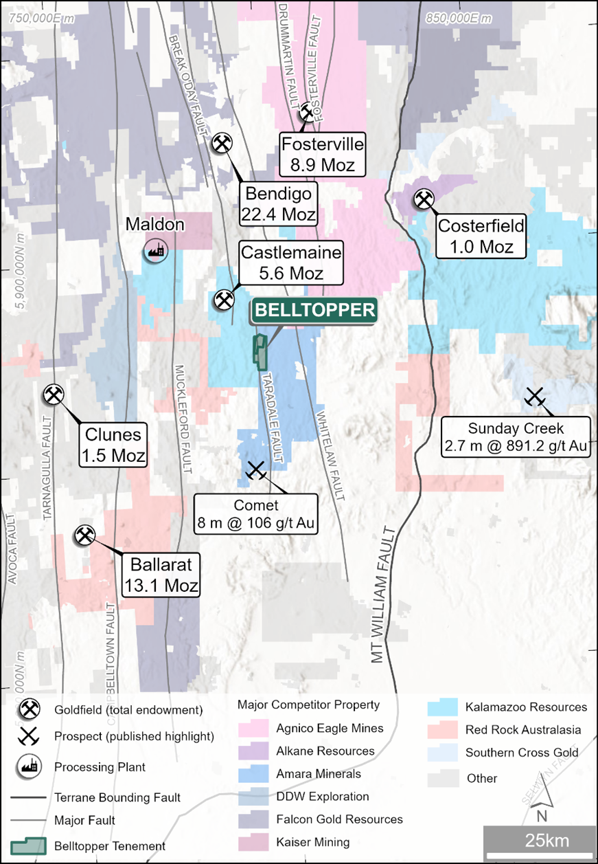
Figure 1. Belltopper Gold Project location map with regional gold occurrences and major structure.2
https://www.globenewswire.com/NewsRoom/AttachmentNg/61849c85-b63e-4b8f-81b2-4a6ceb1336d2
The deposit lies in Lower Ordovician turbiditic sedimentary rocks near two major Devonian granites, the Harcourt and Cobaw batholiths, and this spatial association is a central feature of its interpretation. Historically, the Malmsbury field produced gold from northwest to north-northwest–striking quartz lodes and from alluvial workings, though the Leven Star Reef differs from these more typical auriferous structures. The Leven Star Reef trends northeast, an unusual orientation for the Bendigo Zone, and drilling showed mineralisation to be continuous for approximately 800 m along strike (Figure 2).
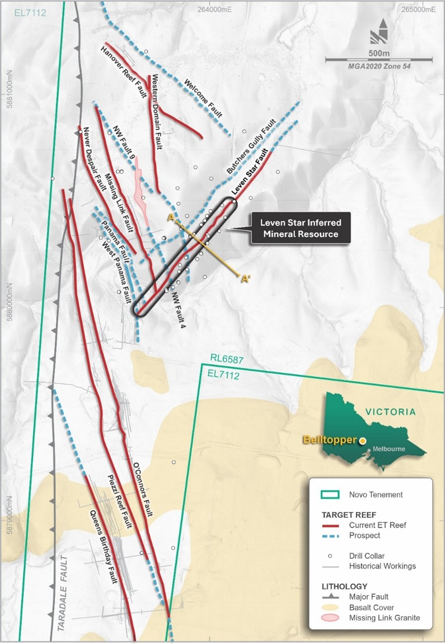
Figure 2. Map of Belltopper area showing the Leven Star Reef Inferred Mineral Resource extent and Exploration Target . Diagram also depicts other current Exploration Target Reefs: Missing Link; Never Despair; O’Connors; Queens/Egyptian; Hanover Fault; Piezzi/Stackyards and Western Domain Fault; in addition to other prospective key target faults.
https://www.globenewswire.com/NewsRoom/AttachmentNg/093f2236-7935-4341-a8cd-d496e72d09d6
Geologically, Leven Star Reef is not a simple quartz-reef deposit. The mineralisation is hosted by a linear quartz-veined stockwork-breccia zone up to 10 m wide, rather than by the reverse fault-hosted laminated to massive quartz veins typical of many Victorian orogenic gold deposits. The Leven Star Reef cuts stratigraphy and post-dates both the dominant upright folding event and earlier reverse fault-hosted quartz veins; establishing it as a younger and geologically distinct event. Host rocks in the Belltopper Hill area show evidence of low-grade contact metamorphism superimposed on earlier regional sub-greenschist metamorphism.
The stockwork-breccia zone is surrounded by an alteration halo up to 12 m wide, dominated by carbonatization, sericitization, sulfidation, and locally silicification. Pyrite is widespread and commonly linked to microfractures and veinlets, whereas arsenopyrite and stibnite are concentrated near stockwork veins and larger quartz structures.
Mineralogically, Leven Star Reef is notable for its complex polymetallic assemblage, which differs from the simpler pyrite-arsenopyrite ± gold association of typical central Victorian orogenic systems.
In addition to native gold, the deposit contains Te-Ni-As-Bi-Sb-Cu-Zn sulphides and Cr-W-F-Sn oxide minerals. Gold occurs both as rare visible grains and as elevated concentrations within arsenopyrite and bismuth minerals, with analyses indicating lattice-bound gold in arsenopyrite.
Geological Interpretation and Wireframes
The Leven Star Reef reaches up to 8 m in width, follows a narrow, brittle fault zone with associated intense fracturing and quartz vein development in the country rock. Deformity and reef width are locally controlled by lithology with some of the best development occurring in coarser-grained sandstone units and/or rheological domain boundaries (e.g. siltstone /coarser-graoined sandstone interfaces).
Three alternative geological/wireframe models for the Leven Star Reef were produced (Models A, B and C – LSA, LSB and LSC). The LSC model was considered the most realistic interpretation of the Leven Star Reef. The LSC model integrates additional downhole data obtained from the recently drilled (2023) diamond hole BTD001. Hole BTD001 successfully extended the Leven Star Reef mineralisation up to 120 m down-dip from the previous MD16 intersections and confirmed the position of the Far East Hanover Fault.
The criteria for wireframe construction were:
- Mineralized indicator grade: 0.3 g/t Au,
- Maximum consecutive internal dilution (downhole) of 2 m,
- No minimum downhole width.
Figure 3 provides an overview of the LSC wireframe and associated faults.
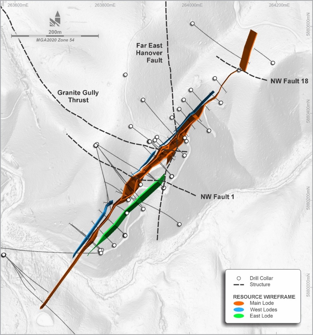
Figure 3. Overview of the LSC model.
https://www.globenewswire.com/NewsRoom/AttachmentNg/0021b208-3319-4523-aa42-4dec39b0c9c1
The BTD001 intersections significantly influence the overall width of LSC at depth. Previous modelling had postulated that the widths identified in MD16 continued at depth, converging at an RL proximal to the intersections now assessed by BTD001 (Figure 4).
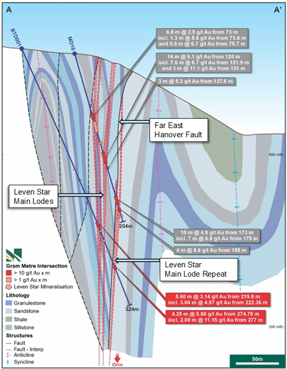
Figure 4. Section of MD16 and BTD001 Novo Drillholes demonstrating the Leven Star Reef and repeat reef to the southeast of the Far East Hanover fault.1, 3 and 4 Section line shown on Figure 2.
https://www.globenewswire.com/NewsRoom/AttachmentNg/8364e9cb-abd4-4683-a691-be0b76c7706b
The true width of mineralisation in hole BTD001 appears to be narrower than previously interpreted. Additionally, the multiple reefs originally interpreted to intersect around the depth of BTD001 are likely to converge at greater depth. This concept is further supported by multiple interpreted Leven Star Reef intersections identified at depth in both MD03 and LSDDH7.
DRILLING, SAMPLING, SAMPLE PREPARATION AND ASSAYING
Leven Star Reef has been drilled intermittently since the 1980s, with the current database reflecting work by several operators over multiple campaigns. This includes Paringa’s early diamond drilling, Pittson’s 1990–1992 diamond drilling, Eureka’s 1994 RC and diamond-tail programme, GBM Resources Ltd (GBM)’s 2007–2008 diamond drilling, GBM–Novo JV drilling in 2021–2022, and Novo’s 2023 BTD hole. Across the deposit, gross drill spacing is about 50 m along strike by 20 m down dip, although spacing is locally variable.
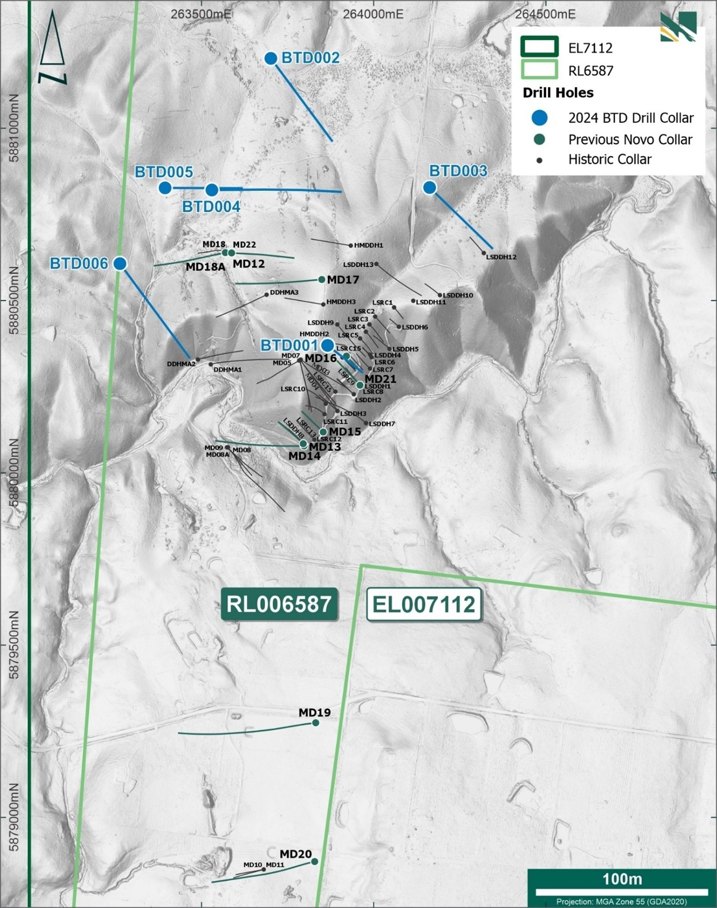
The Leven Star Reef model is based on 44 drillholes; comprising 15 RC and 29 DD drillholes (Table 2). The collar locations are displayed in Figure 5. The DD holes were also used for density analysis and metallurgical testwork.
Table 2. Summary of drillholes used in MRE26.
| Hole type | #holes | #samples | Meters of drilling |
| RC | 15 | 162 | 1,497 |
| DD | 29 | 430 | 5,959 |
| Total | 44 | 592 | 7,456 |
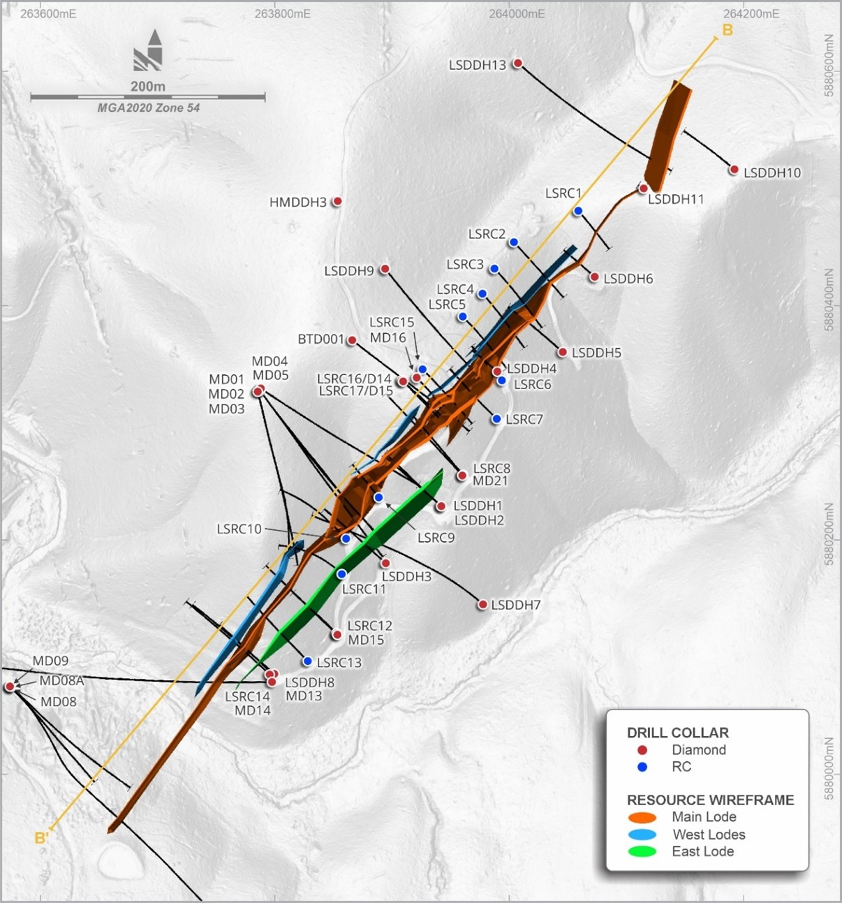
Figure 5. Leven Star Reef collar plan - input drillhole data.
https://www.globenewswire.com/NewsRoom/AttachmentNg/a64fdf5f-9b84-4f4c-ab29-36d72780a211
Survey control is mixed, reflecting the age of the drilling. Most Pittson and Eureka collars were originally surveyed by a registered surveyor using a theodolite in AMG84 Zone 55, while some older DDHMA collars are less reliable because they were digitized from historic plans. Novo later validated most collars in the field, and a high-resolution LiDAR survey flown in December 2022 helped confirm collar locations across Belltopper and convert them into MGA94 Zone 55. Downhole survey methods also evolved through time: earlier diamond holes used magnetic single-shot surveys at collar, nominal 50 m intervals, and end of hole, while recent Novo drilling used modern tools such as the REFLEX EZ-TRAC and Boart Longyear TruShot, typically surveyed from 6 m depth and then every 25 m.
Diamond core drilling is regarded as the most appropriate drilling method at Leven Star Reef because it provides geological, density, and metallurgical information. Historical and recent diamond drilling programmes used standard HQ and NQ wireline methods. Core was logged and photographed, then split longitudinally, with half core submitted for assay and the remaining half retained. Sampling was to geological boundaries, over 0.3–2.0 m historically and 0.3–1.3 m in the recent Novo programme, with 1 m the preferred sample length. RC drilling was all pre-2008, to a maximum depth of 118 m, and samples were split with a Jones riffle splitter to about 3–5 kg. However, historical RC methods, sample security, and recovery documentation are sparse.
Core recovery was generally good (>90 %), though early (pre-2007) core recovery was not well-recorded. Some core loss is noted, particularly in highly fragmented zones where fines loss was high. Core loss zones were treated as zero grade in any significant intersection calculation.
Sample preparation and assaying are considered broadly acceptable, but with an important caveat. Pre-2008 documentation is incomplete. Fire assay with AAS finish is preferred and was used for most later work, including Novo’s recent ALS Adelaide programme, which used a 50 g fire assay charge after pulverizing to P85 75 µm. Some early Eureka samples were assayed by aqua regia digest, which is suboptimal for Leven Star Reef given the method is a partial extraction and understates refractory gold. Statistical comparisons in the report indicate that fire assay grades tend to be higher than aqua regia grades.
QAQC is weakest in the early drilling and much better from 2008 onward. Pre-GBM data include only a small number of blanks and poorly documented standards. By contrast, GBM and Novo inserted Certified Reference Materials (CRM) and blanks regularly. Most CRM results were acceptable, although GBM’s OREAS232 and Novo’s OREAS264 were considered marginal because of bias or outlier behaviour. Blank performance was good, with only two low-level breaches in 297 analyses. Duplicate data suggests little coarse gold, as RC and half-core duplicates showed low variability. Check assays were more variable, showing a positive bias of about 8–13%. This will reflect some “between” laboratory variation.
The CPs conclude that drilling, sampling, and QC are adequate for use in the MRE, but historical data gaps, recovery issues, and some QC weaknesses mean confidence remains low to moderate. This has been considered by the CPs during classification.
ESTIMATION APPROACH
The Leven Star Reef estimate was built from a staged workflow: data validation, data preparation, exploratory data analysis, geological interpretation and modelling, compositing, assessment of extreme values, variography, block model optimisation, block modelling/grade estimation, model validation, depletion assessment, classification and reporting. Datamine RM Pro software was used for estimation and Supervisor for statistical analysis. The input database includes historical and recent drilling from several campaigns. The Leven Star Reef block model is based on RC and DD, with DD holes also used to support density analysis and metallurgical work. Topography, oxidation and fresh-rock surfaces, and several fault wireframes were incorporated into the geological model. Only gold grade is reported.
Geological interpretation is based on the LSC model, integrates the 2023 BTD001 diamond hole, which extended the interpreted mineralisation down dip and improved understanding of the Far East Hanover Fault (Figure 3 and Figure 4). The LSC model includes the main Leven Star Reef structure and several minor parallel hanging-wall and footwall reefs.
For estimation, drillhole data were coded by mineralized domain, fault area and weathering state. Contact analysis found no strong grade break between oxide, transitional and fresh material sufficient to justify separate estimation domains at this stage, so weathering states were combined within each mineralized domain. Samples were composited to 1 m within domain boundaries. Gold top-cuts were applied only where required, notably in the 100 domain.
Given the current understanding of the geology (faulting occurring post-mineralisation) and the initial analysis, it was decided to combine the mineralized reefs across the faults, and to combine the oxide, transitional and fresh material by domain. The final estimation domain coding (Domain) is summarized in Table 3 and shown in Figure 6.
Table 3. Domain coding for gold mineralisation.
| Domain | Description |
| 100 | LSC Main, oxide, transitional and fresh material |
| 200 | LSC NW, oxide, transitional and fresh material |
| 300 | LSC NW South, oxide, transitional and fresh material |
| 400 | LSC SE, oxide, transitional and fresh material |
| 500 | LSC Far N, oxide, transitional and fresh material |
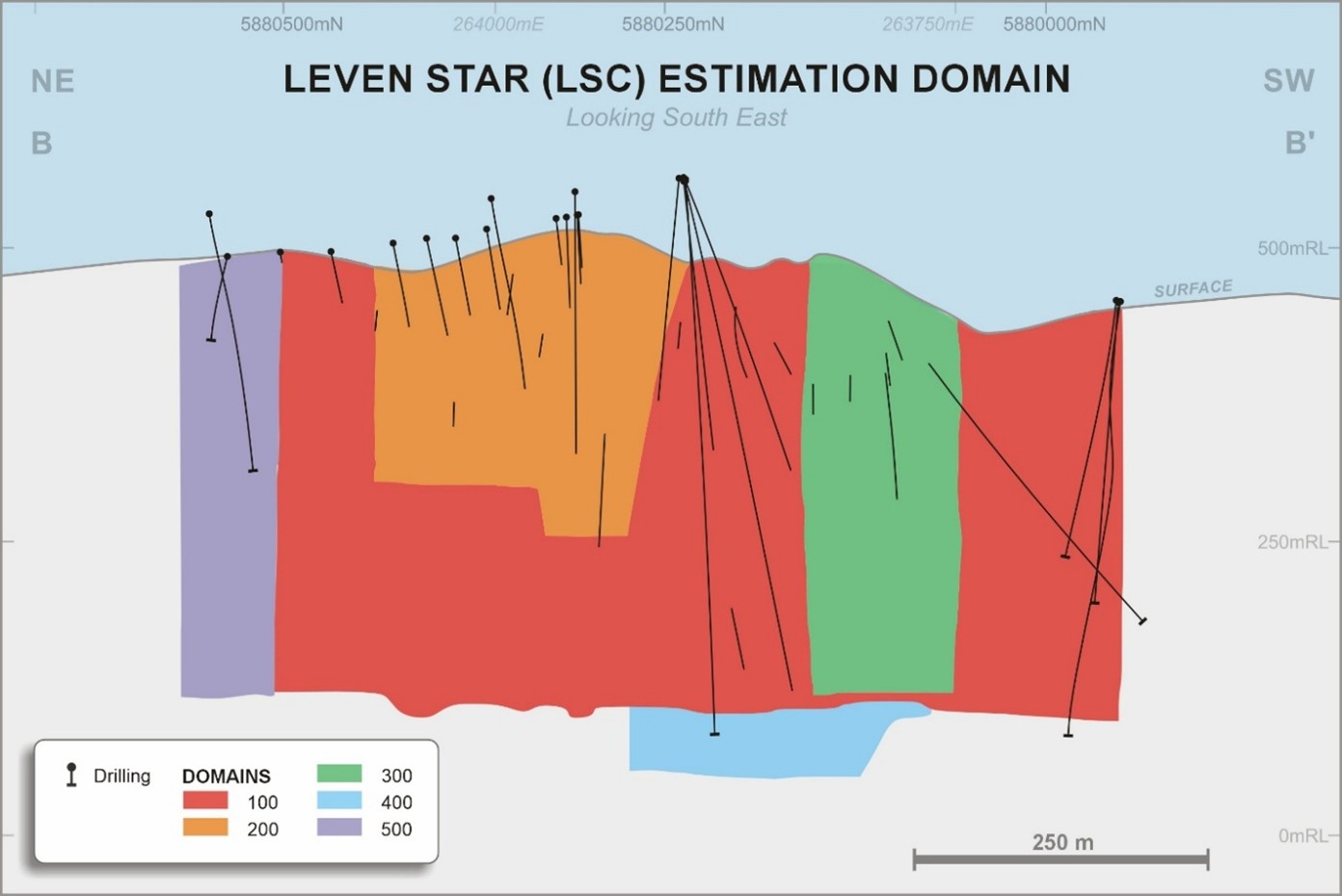
Figure 6. Long section showing estimation domains in LSC.
https://www.globenewswire.com/NewsRoom/AttachmentNg/2fb0b02f-41c7-4e4a-bfe0-32df32b38782
Grade estimation used Ordinary Kriging into a rotated block model aligned with the approximate strike of mineralisation. The block model used parent blocks of 2 m (E) by 40 m (N) by 30 m (RL), sub-celled to 0.5 m (E) by 2 m (N) by 2 m (RL) determined by Quantitative Kriging Neighbourhood Analysis (QKNA).
An initial (P1) search ellipse of 110 m by 30 m by 15 m was defined based on the results of the variography and assessment of the data coverage. A minimum of eight and maximum of 25 samples was used for the initial search pass. Second pass (P2) was two times the initial search ellipse with a minimum of eight and maximum of 25 samples. Third pass (P3) was three times the initial search with a minimum of four and maximum of 15 samples. The fourth pass (P4) was eight times the initial search pass with a minimum of two and maximum of 15 – run to populate all blocks. All passes had a maximum of three samples per drillhole applied for the gold estimate.
Figure 7 shows a long-section of the Leven Star Reef displaying block grades for Domain 100 (Main Lode) and overall extent of the classified MRE.
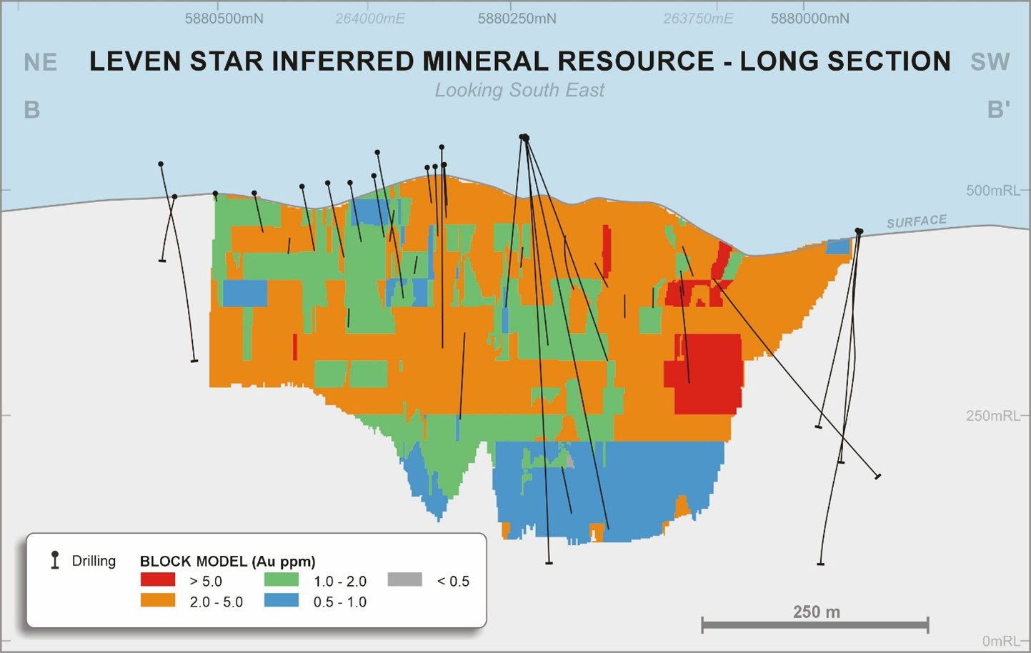
Figure 7. Long-section showing block grades and overall extent of the classified MRE.
https://www.globenewswire.com/NewsRoom/AttachmentNg/a7bf0dee-3f2a-4ab0-b523-30804621ec85
Validation included global comparisons of composites and block estimates, visual inspection in long section, and swath plots. The gold estimate for the main (100) domain validated well against declustered composites (<1% difference).
Extrapolation occurs along strike and down dip, with the maximum extrapolated distance from a drill hole being 180 m down-dip. Passes 1 (0.5x the variogram range) and 2 (1x the variogram range) of the search area are defined as interpolation. Pass 3 (1.5x the variogram range) is defined as extrapolation. Approximately 21% of the reported gold ounces are based on extrapolation, equivalent to 20% of the reported tonnes.
The MRE is global in nature. No depletion has been applied to the model. It is understood that minimal mining has taken place on the Leven Star Reef.
Bulk density measurements were determined by Novo personnel using the weight-in-water/weight-in-air method. A total of 52 measurements fall within the mineralisation. The following bulk density values were applied: oxide mineralisation 2.50 t/m3 (waste 2.35 t/m3); transition mineralisation 2.60 t/m3 (waste 2.45 t/m3); and fresh mineralisation 2.65 t/m3 (waste 2.70 t/m3). Tonnages are reported on a dry basis.
MINING AND METALLURGICAL ASSUMPTIONS INCLUDING REASONABLE PROSPECTS FOR EVENTUAL ECONOMIC EXTRACTION (RPEEE)
Reasonable Prospects for Eventual Economic Extraction (RPEEE)
MRE26 has been reported as an underground operation, within Datamine MSO optimized stope shapes to support the assessment of RPEEE.
The optimized MSO stope shapes were estimated with the following indicative parameters:
- Gold price: AU$5,250 per oz gold (equivalent to US$3,675 per oz gold based on a consensus US$:AU$ exchange rate of 0.7).
- Bulk density applied: oxide mineralisation 2.50 t/m3 (waste 2.35 t/m3); transition mineralisation 2.60 t/m3 (waste 2.45 t/m3); and fresh mineralisation 2.65 t/m3 (waste 2.70 t/m3).
- AU$162/t mining cost (including grade control).
- AU$119/t processing cost (including G&A and surface haulage).
- Metallurgical recovery at 88%.
- Mining is based on sub-level open stoping with 15 m level to level separation, mining recovery of 90%, minimum mining width at 1.5 m and 0.2 m HW and FW dilution.
- Victorian State Royalty of 2.75%.
- Discount factor 8%.
Mining costs were defined on a “comparison” basis at a rate of 250,000 tonnes per annum.
The Leven Star Reef MRE was reported for an underground operation. A cut-off grade of 1.9 g/t Au was applied. This was calculated from the inputs provided to the MSO optimisation process (see above). The MRE is reported diluted within the MSO optimised shapes.
A time period of between 5 to 10 years is considered appropriate for “eventual economic extraction” for Leven Star Reef, noting that gold price- operating expenditure, and regulatory conditions may change during the period.
Metallurgical Assumptions
The Leven Star Reef has undergone minimal historical metallurgical testing, with the most recent programme conducted in 2023 on a 28 kg composite sample derived from fresh sulphide-bearing drill core. The material averaged 4.5 g/t gold, with notable arsenic and minor antimony content. Testing followed a staged approach, including gravity recovery, flotation, cyanide leaching, and diagnostic leaching, but excluded comminution studies.
Results indicate that gravity recovery is limited, achieving only 12% gold recovery due to the predominance of fine (<75 µm), refractory gold. In contrast, flotation proved highly effective, particularly at a grind size of P80 90 µm, yielding a concentrate with strong gold grades and achieving approximately 92% recovery from flotation feed, corresponding to about 93% overall recovery when combined with gravity.
Cyanide leaching performed poorly, with recoveries near 11% across varying grind sizes, demonstrating that conventional gravity/ CIL processing would be ineffective. Diagnostic leaching on gravity tails revealed that most unrecovered gold is locked within sulphides, especially arsenopyrite, explaining the low leachability. Overall, the results highlight flotation as the most viable processing route for this mineralisation.
The testwork conclusion was that Leven Star sulphide mineralisation is strongly refractory. The preferred process route is therefore flotation to a sulphide concentrate. It is assumed that mineralisation would be fed to a process plant with a flotation circuit within reasonable haulage distance. Subject to further testwork, it is assumed that a flotation concentrate would be produced for direct sale.
Context of the Leven Star Reef at Belltopper
As a stand-alone MRE, Leven Star Reef is small. However, it is part of an Exploration Target covering a large part of the Novo Belltopper project area (Table 4)1.
Table 4. Exploration Target for the Belltopper Project. This Exploration Target includes the Leven Star Reef
| Metric | Low case (approximation) | High case (approximation) |
| Tonnage range | 2.1 Mt | 3.1 Mt |
| Grade range | 6.7 g/t Au | 8.9 g/t Au |
Figures may not compute due to rounding.
Clarification statement: An Exploration Target as defined in the JORC Code (2012) is a statement or estimate of the exploration potential of a mineral deposit in a defined geological setting where the statement or estimate, quoted as a range of tonnes and a range of grade (or quality), relates to mineralisation for which there has been insufficient exploration to estimate a Mineral Resource. Accordingly, these figures are not Mineral Resource or Ore Reserve estimates as defined in the JORC Code (2012). The potential quantities and grades referred to above are conceptual in nature and there has been insufficient exploration to estimate a Mineral Resource, and it is uncertain if further exploration will result in the estimation of a Mineral Resource. These figures are based on the interpreted continuity of mineralisation and projection into unexplored ground often around historical workings. The Exploration Target has been reported in accordance with the JORC Code (2012) as detailed in the Company’s ASX announcement released on 11 February 2026 (available to view at www.asx.com.au). The Tonnage range for the exploration target is 2.1 Mt to 3.1 Mt, and the Grade range is 6.7 g/t Au to 8.9 g/t Au. Dr Christopher Doyle (MAIG) and Dr Simon Dominy (FAusIMM CPGeo; FAIG RPGeo; FGS CGeol), are the qualified persons, as defined under National Instrument 43-101 Standards of Disclosure for Mineral Projects, responsible for, and having reviewed and approved, the technical information relating to the Exploration Target . Dr Doyle is Novo’s Exploration Manager - Victoria and Dr Dominy is a Technical Advisor to Novo.
The Leven Star Reef represents one out of eight individual reefs that comprise the Exploration Target . The Leven Star Reef Mineral Resource forms part of the broader Belltopper mineralised system. Novo has previously reported an Exploration Target for Belltopper, of which Leven Star Reef is one component. The Exploration Target is conceptual in nature and is not a Mineral Resource. There has been insufficient exploration to estimate Mineral Resources for all components of the Exploration Target , and it is uncertain whether further exploration will result in additional Mineral Resources being estimated. Further drilling will be required to assess the potential extensions and additional reefs.
Forward Work Plan - Drilling
Near-term scoping level drilling (ca. 100 m x 100 m) of the remaining seven reefs is planned to gain confidence across all Exploration Target reefs and/or to assess additional known historic reefs that currently sit outside of the Exploration Target . Longer term resource-level drilling of the seven alternate (or additional known) reefs will be contingent on initial scoping-level drilling results.
The goal is to grow the resource base at Belltopper via incremental growth at Leven Star in parallel with the seven additional Exploration Target Reefs and/or any other known historic reefs that may ultimately be included.
SUSTAINABILITY AND ENVIRONMENT
To undertake mining in Victoria, applicants must follow the structured process outlined by the Mineral Resources (Sustainability) Act 1990 (Vic) and the Mineral Resource (Sustainable Development) (Mineral Industries) Regulations 2019 (Vic). This process includes obtaining necessary tenure, planning permits and other approvals under the associated legislation. Environmental approval for the construction and commencement of mining is obtained under the Environmental Effects Act 1978 (Vic). The assessment is undertaken by the Department of Transport and Planning. The Environmental Effects Act 1978 (Vic) provides that where proposed works may have a significant effect on the environment, either a proponent or a decision-maker may refer these works (or project) to the Minister for Planning for advice as to whether an Environment Effects Statement (EES) is required. Additional approvals under other legislation are required, including (for example) the requirement for a Cultural Heritage Management Plan under the Aboriginal Heritage Act 2006 (Vic) .
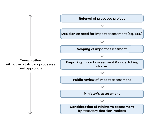
Figure 8. Overview of process under the Environmental Effects Act,1978
https://www.globenewswire.com/NewsRoom/AttachmentNg/519381f3-2396-4514-ac69-79cb7adac7c6
The approval pathway will be determined by the level of disturbance the proposed project will have on the surface ecology. Novo has commenced planning and scheduling the necessary surveys and studies required to understand the possible impact on the environment and surrounds. Studies required prior to lodging an environmental approval application include flora, fauna, surface water and hydrology, air pollution and possible impacts to the community. It can take a minimum of three years to collect and assess the environmental data and to obtain the Primary and Secondary approvals (pending outcomes of all relevant studies) required to commence construction and mining.
MINERAL RESOURCE CLASSIFICATION
The Mineral Resources are classified in accordance with the JORC Code (2012) for reporting of Exploration Results, Mineral Resources, and Ore Reserves.
The model has been classified on a domain-by-domain basis; in practical terms a wireframe was constructed to encapsulate material meeting the criteria for each classification category and used to delineate and code the model. Inferred Mineral Resources have been defined at Leven Star Reef. No areas of the resource have been classified as Measured or Indicated Mineral Resources.
Areas classified as Inferred Mineral Resources are informed by drilling spaced from 20 m up to >50 m, and have been estimated within the first, second, or the third estimation pass with a slope of regression greater than zero. Individual domains have been reviewed and classified accordingly. Areas that have not been estimated in the third pass have been categorized as ‘unclassified’ and have not been reported.
TECHNICAL REPORT
Novo will file a technical report (as defined in National Instrument 43-101 Standards of Disclosure for Mineral Projects) within 45 days of the date of this news release.
Authorised for release by the Board of Directors.
CONTACT
| Investors: Mike Spreadborough +61 8 6400 6100 info@novoresources.com | North American Queries: Leo Karabelas +1 416 543 3120 leo@novoresources.com | Media: Peter Taylor +61 412 036 231 peter@nwrcommunication.com.au |
QP STATEMENT
Ms Janice Graham (MAusIMM CPGeo; MAIG) and Dr Simon Dominy (FAusIMM CPGeo; FAIG RPGeo; FGS CGeol) are the qualified persons, as defined under National Instrument 43-101 Standards of Disclosure for Mineral Projects, responsible for, and having reviewed and approved, the technical information contained in this news release relating to the Leven Star Mineral Resource Estimate (MRE). Ms Graham is a Principal Consultant and full-time employee of Snowden Optiro and Dr Dominy is a Technical Advisor to Novo.
Dr Christopher Doyle (MAIG) and Dr Simon Dominy (FAusIMM CPGeo; FAIG RPGeo; FGS CGeol), are the qualified persons, as defined under National Instrument 43-101 Standards of Disclosure for Mineral Projects, responsible for, and having reviewed and approved, the technical information contained in this news release relating to the Belltopper Exploration Target . Dr Doyle is Novo’s Exploration Manager - Victoria and Dr Dominy is a Technical Advisor to Novo.
JORC COMPLIANCE STATEMENTS
Mineral Resource
The information in this release pertaining to the Leven Star Reef Mineral Resource Estimate at the Belltopper Gold Project is based on, and fairly represents, information and supporting documentation compiled by Ms Janice Graham (MAusIMM CPGeo; MAIG) and Dr Simon Dominy (FAusIMM CPGeo; FAIG RPGeo; FGS CGeol). Ms Graham is a full-time employee of Snowden Optiro. Dr Dominy is an independent technical advisor to Novo Resource Corp. Ms Graham and Dr Dominy have sufficient experience relevant to the styles of mineralisation and type of deposits under consideration and to the activity being undertaken to individually qualify as a Competent Person as defined in the 2012 Edition of the “Australasian Code for Reporting of Exploration Results, Mineral Resources and Ore Reserves”. Ms Graham and Dr Dominy consent to the inclusion in the report of the matters based on this information in the form and context in which it appears.
Belltopper Exploration Target
Novo initially announced its updated 2026 Exploration Target for the Belltopper Gold Project to ASX on 11 February 2026 in its announcement entitled “Novo Delivers Significant Increase to Belltopper Exploration Target ” (which is available to view at www.asx.com.au) (Exploration Target Announcement).
The information in this announcement that relates to the Belltopper Exploration Target is based on information compiled by:
(a) Dr Christopher Doyle, a Competent Person who is a Member of the Australasian Institute of Geoscientists (MAIG). Dr Doyle is Exploration Manager – Victoria for Novo and is a full-time employee of Novo. Dr Doyle has sufficient experience that is relevant to the style of mineralisation and type of deposit under consideration and to the activity being undertaken to qualify as a Competent Person as defined in the 2012 Edition of the “Australasian Code for Reporting of Exploration Results, Mineral Resources and Ore Reserves”. Dr Doyle consents to the inclusion in this announcement of the matters based on his information in the form and context in which it appears; and
(b) Dr Simon Dominy, a Competent Person who is a Fellow of the Australasian Institute of Geoscientists (FAIG RPGeo), the Australasian Institute of Mining and Metallurgy (FAusIMM CPGeo) and Chartered Fellow of the Geological Society of London (FGS CGeol). Dr Dominy is a Technical Advisor contracted to Novo. Dr Dominy has sufficient experience that is relevant to the style of mineralisation and type of deposit under consideration and to the activity being undertaken to qualify as a Competent Person as defined in the 2012 Edition of the “Australasian Code for Reporting of Exploration Results, Mineral Resources and Ore Reserves”. Dr Dominy consents to the inclusion in this announcement of the matters based on his information in the form and context in which it appears.
As a basis for the Belltopper Exploration Target , Novo applied its geological understanding of the reef network at the Belltopper Gold Project, drawing upon 3D reconstruction of historic mining and exploration data, drilling data, structural and geochemical data, field mapping (including high-resolution LiDARTM interpretation), and surface rock chip sampling. Further information about Novo’s Exploration Target at Belltopper, along with a more detailed explanation of the basis for the Exploration Target (including a specific description of the level of exploration activity already completed at Belltopper), is contained in the Exploration Target Announcement.
Previous Exploration Results
The information in this news release that relates to Exploration Results at the Belltopper Gold Project is extracted from Novo’s ASX announcements listed in endnotes 1, 3 and 4 below, each of which is available to view at www.asx.com.au. The Company confirms that it is not aware of any new information or data that materially affects the information included in the original market announcements and that all material assumptions and technical parameters underpinning the estimates in the market announcements continue to apply and have not materially changed. The Company confirms that the form and context in which the Competent Person’s findings are presented have not been materially modified from the original market announcements.
FORWARD-LOOKING STATEMENTS
Some statements in this news release may contain “forward-looking statements” within the meaning of Canadian and Australian securities law and regulations. In this news release, such statements include but are not limited to planned exploration activities and the timing of such. These statements address future events and conditions and, as such, involve known and unknown risks, uncertainties and other factors which may cause the actual results, performance or achievements to be materially different from any future results, performance or achievements expressed or implied by the statements. Such factors include, without limitation, customary risks of the resource industry and the risk factors identified in Novo’s annual information form for the year ended December 31, 2025 (which is available under Novo’s profile on SEDAR+ at www.sedarplus.ca and at www.asx.com.au), in the Company’s options prospectus dated 9 March 2026, and in the Company’s prospectus dated 2 August 2023 which is available at www.asx.com.au. Forward-looking statements speak only as of the date those statements are made. Except as required by applicable law, Novo assumes no obligation to update or to publicly announce the results of any change to any forward-looking statement contained or incorporated by reference herein to reflect actual results, future events or developments, changes in assumptions or changes in other factors affecting the forward-looking statements. If Novo updates any forward-looking statement(s), no inference should be drawn that the Company will make additional updates with respect to those or other forward-looking statements.
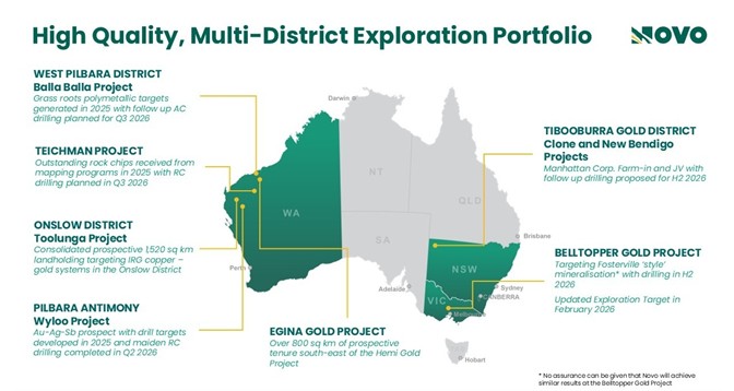
ABOUT NOVO
Novo is an Australian based gold explorer listed on the ASX and the TSX focussed on discovering standalone gold and copper projects with > 1 Moz development potential. Novo is an innovative explorer with a significant land package covering approximately 4,160 square kilometres in the Pilbara region of Western Australia, which includes the Toolunga Project in the Onslow District, along with the 22 square kilometre Belltopper project in the Bendigo Tectonic Zone of Victoria. In addition to the above, Novo is part of a prospective farm in agreement in New South Wales.
Novo has a significant investment portfolio and a disciplined program in place to identify value accretive opportunities that will build further value for shareholders.
Please refer to Novo’s website for further information including the latest corporate presentation.
#Refer to De Grey’s ASX Announcement, Hemi Gold Project Mineral Resource Estimate (MRE) 2024, dated 14 November 2024. No assurance can be given that a similar (or any) commercially viable mineral deposit will be determined at Novo’s Becher Project.
https://www.globenewswire.com/NewsRoom/AttachmentNg/3254fc19-2566-40e9-84f3-2f76cd464b20
______________________________
1 Refer to Novo’s ASX announcement dated 11 February 2026 – Novo delivers significant increase to Belltopper exploration target.
2 See the following for source documents in relation to the historical gold production figures for Bendigo, Fosterville, Costerfield, Castlemaine and Ballarat. Wilson, C. J. L., Moore, D. H., Vollgger, S. A., & Madeley, H. E. (2020). Structural evolution of the orogenic gold deposits in central Victoria, Australia: The role of regional stress change and the tectonic regime. Ore Geology Reviews, 120, 103390. Phillips, G. N., & Hughes, M. J. (1996). The geology and gold deposits of the Victorian gold province. Ore Geology Reviews, 11(5), 255-302. Costerfield Operation, Victoria, Australia, NI 43-101 Technical Report, March 2024; Agnico Eagle Mines Detailed Mineral Reserve and Mineral Resources Statement (as at December 31, 2023). Agnico Eagle Mines Limited, Fosterville Gold Mine, Retrieved August 21, 2024, from Agnico Eagle Website. For Comet and Sunday Creek exploration results, refer: Great Pacific Gold (TSXV:GPAC) Company TSXV release dated 11 January 2024, and Southern Cross Gold (ASX:SXG) Company ASX release dated 5 March 2024, respectively. Production figures for Bendigo, Castlemaine and Ballarat include combined alluvial and hard rock production. Gold endowment for Fosterville includes historic production + reserves + resources as at 31/12/2023. Gold endowment for Costerfield equals historic production + resource (including reserves) as at 28/03/2024. Novo has not conducted data verification (as that term is defined in National Instrument 43-101 Standards of Disclosure for Mineral Projects and JORC 2012) in respect of the data set out in Figure 1 and therefore is not to be regarded as reporting, adopting or endorsing those results/figures. No assurance can be given that Novo will achieve similar results at Belltopper.
3 Refer to Novo’s ASX announcement dated 25 September 2024 – Belltopper mineralisation modelling defines prospectivity
4 Refer to Novo’s ASX announcement dated 4 June 2024 – Reissue of Announcement: Significant results from diamond drilling at Belltopper, Victoria.
APPENDIX 1: BELLTOPPER DRILL COLLARS
| Hole ID | Hole Type | Depth (m) | Easting | Northing | RL AHD (m) | Collar Dip (°) | Collar Azimuth (MGA94 55) (°) | Collar Azimuth (Mag) (°) | Company | Date completed |
| BTD001 | DD | 323.7 | 263866.02 | 5880369.85 | 524.18 | -66 | 128.484 | 118.984 | NOVO | 28-Nov-23 |
| BTD002 | DD | 594 | 263701.31 | 5881202.77 | 457.18 | -60 | 145.117 | 135.617 | NOVO | 21-Dec-23 |
| BTD003 | DD | 389.7 | 264162.29 | 5880827.97 | 489.97 | -51.05 | 135.07 | 125.57 | NOVO | 18-Jan-24 |
| BTD004 | DD | 521 | 263530.06 | 5880820.71 | 471.69 | -45 | 90.23 | 80.73 | NOVO | 08-Feb-24 |
| BTD005 | DD | 299.9 | 263394.65 | 5880825.96 | 471.94 | -50 | 90.495 | 80.995 | NOVO | 19-Feb-24 |
| BTD006 | DD | 400.6 | 263263.53 | 5880606.13 | 470.22 | -37.88 | 144.53 | 135.03 | NOVO | 05-Mar-24 |
| MD01 | DD | 352.2 | 263787.47 | 5880326.69 | 526.36 | -57 | 144.5 | 135 | GBM | 20-Dec-07 |
| MD02 | DD | 262 | 263787.42 | 5880326.77 | 526.39 | -50 | 144.5 | 135 | GBM | 10-Jan-08 |
| MD03 | DD | 478.5 | 263787.36 | 5880326.85 | 526.39 | -65 | 144.5 | 135 | GBM | 01-Nov-08 |
| MD04 | DD | 255 | 263788.00 | 5880328.62 | 526.37 | -51.5 | 124.5 | 115 | GBM | 26-Jan-08 |
| MD05 | DD | 266.9 | 263785.35 | 5880325.81 | 526.34 | -50 | 166.5 | 157 | GBM | 08-Feb-08 |
| MD06A | DD | 426.8 | 263785.10 | 5880326.89 | 526.36 | -66 | 165.5 | 156 | GBM | 24-Feb-08 |
| MD07 | DD | 249 | 263783.43 | 5880326.00 | 526.32 | -55.5 | 239.5 | 230 | GBM | 03-Mar-08 |
| MD08 | DD | 241.2 | 263575.14 | 5880074.01 | 434.02 | -54.9 | 134.7 | 125.2 | GBM | 09-Apr-08 |
| MD08A | DD | 450.3 | 263574.36 | 5880074.15 | 434.05 | -55.5 | 134.5 | 125 | GBM | 02-May-08 |
| MD09 | DD | 259.8 | 263573.87 | 5880074.24 | 434.07 | -65.9 | 134.5 | 125 | GBM | 12-May-08 |
| MD10 | DD | 191.3 | 263680.28 | 5878848.91 | 475.87 | -60 | 254.5 | 245 | GBM | 25-May-08 |
| MD11 | DD | 261 | 263680.66 | 5878849.04 | 475.87 | -70 | 259.3 | 249.8 | GBM | 05-Jun-08 |
| MD12 | DD | 999.8 | 263587.00 | 5880641.00 | 471.52 | -85.5 | 279.5 | 270 | GBM | 17-Mar-10 |
| MD13 | DD | 112.4 | 263795.58 | 5880084.40 | 457.50 | -30 | 315 | 305.5 | GBM | 23-Dec-21 |
| MD14 | DD | 365.5 | 263797.55 | 5880078.04 | 456.24 | -50 | 270 | 260.5 | GBM | 24-Jan-22 |
| MD15 | DD | 131.2 | 263853.37 | 5880118.38 | 452.71 | -50 | 315 | 305.5 | GBM | 03-Feb-22 |
| MD16 | DD | 204 | 263921.11 | 5880337.81 | 518.16 | -73 | 135 | 125.5 | GBM | 15-Feb-22 |
| MD17 | DD | 380 | 263849.25 | 5880561.10 | 523.92 | -50 | 265 | 255.5 | GBM | 09-Mar-22 |
| MD18 | DD | 320 | 263569.06 | 5880639.13 | 470.11 | -50 | 260 | 250.5 | GBM | 29-Mar-22 |
| MD18A | DD | 35 | 263569.46 | 5880639.23 | 470.13 | -50 | 260 | 250.5 | GBM | 30-Mar-22 |
| MD19 | DD | 553.9 | 263831.60 | 5879274.76 | 472.01 | -50 | 260 | 250.5 | GBM | 03-May-22 |
| MD20 | DD | 551.4 | 263828.50 | 5878871.91 | 477.38 | -58 | 260 | 250.5 | GBM | 07-Jun-22 |
| MD21 | DD | 255.5 | 263959.98 | 5880254.29 | 481.10 | -68.4 | 318.6 | 309.1 | GBM | 27-Jun-22 |
| MD22 | DD | 252.8 | 263587.28 | 5880638.16 | 471.78 | -45.9 | 93.9 | 84.4 | GBM | 10-Jul-22 |
| LSRC1 | RC | 87 | 264059.03 | 5880480.22 | 492.41 | -60 | 135.5 | 126 | Eureka | 20-Aug-94 |
| LSRC2 | RC | 111 | 264004.09 | 5880453.50 | 495.34 | -55 | 135.5 | 126 | Eureka | 22-Aug-94 |
| LSRC3 | RC | 111 | 263987.44 | 5880430.88 | 498.14 | -55 | 135.5 | 126 | Eureka | 26-Aug-94 |
| LSRC4 | RC | 110 | 263977.25 | 5880409.48 | 501.61 | -55 | 135.5 | 126 | Eureka | 27-Aug-94 |
| LSRC5 | RC | 110 | 263960.40 | 5880390.00 | 507.44 | -55 | 135.5 | 126 | Eureka | 28-Aug-94 |
| LSRC6 | RC | 70 | 263993.79 | 5880335.47 | 496.58 | -56 | 315.5 | 306 | Eureka | 29-Aug-94 |
| LSRC7 | RC | 105 | 263989.42 | 5880302.66 | 491.44 | -55 | 315.5 | 306 | Eureka | 29-Aug-94 |
| LSRC8 | RC | 112 | 263960.64 | 5880254.82 | 481.32 | -55 | 315.5 | 306 | Eureka | 30-Aug-94 |
| LSRC9 | RC | 73 | 263888.69 | 5880235.61 | 474.55 | -60 | 315.5 | 306 | Eureka | 01-Sep-94 |
| LSRC10 | RC | 112 | 263860.81 | 5880200.34 | 469.75 | -55 | 315.5 | 306 | Eureka | 04-Sep-94 |
| LSRC11 | RC | 96 | 263857.09 | 5880170.10 | 463.53 | -55 | 315.5 | 306 | Eureka | 05-Sep-94 |
| LSRC12 | RC | 82 | 263852.64 | 5880119.70 | 452.86 | -50 | 315.5 | 306 | Eureka | 07-Sep-94 |
| LSRC13 | RC | 118 | 263828.12 | 5880095.91 | 454.24 | -50 | 315.5 | 306 | Eureka | 08-Sep-94 |
| LSRC14 | RC | 100 | 263798.14 | 5880084.18 | 456.59 | -50 | 315.5 | 306 | Eureka | 09-Sep-94 |
| LSRC15 | RC | 100 | 263926.07 | 5880344.94 | 517.80 | -50 | 135.5 | 126 | Eureka | 11-Sep-94 |
| LSRC16/D14 | RC/DD | 101.1 | 263908.39 | 5880335.61 | 518.96 | -60 | 135.5 | 126 | Eureka | 23-Sep-94 |
| LSRC17/D15 | RC/DD | 84 | 263909.51 | 5880334.60 | 518.75 | -50 | 135.5 | 126 | Eureka | 03-Oct-94 |
| HMDDH1 | DD | 180.7 | 263933.48 | 5880659.32 | 512.75 | -50 | 279.5 | 270 | Pittson | 16-Dec-91 |
| HMDDH2 | DD | 70 | 263872.24 | 5880377.30 | 523.19 | -50 | 99.5 | 90 | Pittson | 22-Dec-91 |
| HMDDH3 | DD | 176.5 | 263853.66 | 5880488.54 | 526.55 | -50 | 279.5 | 270 | Pittson | 31-Dec-91 |
| LSDDH1 | DD | 100.6 | 263942.09 | 5880228.14 | 474.18 | -50 | 311.5 | 302 | Pittson | 01-May-90 |
| LSDDH2 | DD | 162.4 | 263942.09 | 5880228.14 | 474.18 | -65 | 311.5 | 302 | Pittson | 09-May-90 |
| LSDDH3 | DD | 110.4 | 263894.70 | 5880179.43 | 450.94 | -50 | 311.5 | 302 | Pittson | 13-May-90 |
| LSDDH4 | DD | 49.5 | 263989.89 | 5880343.02 | 500.13 | -55 | 311.5 | 302 | Pittson | 15-May-90 |
| LSDDH5 | DD | 140.7 | 264045.76 | 5880359.72 | 473.23 | -65 | 311.5 | 302 | Pittson | 18-May-90 |
| LSDDH6 | DD | 60.5 | 264073.00 | 5880423.93 | 476.30 | -55 | 311.5 | 302 | Pittson | 19-May-90 |
| LSDDH7 | DD | 333 | 263977.71 | 5880144.28 | 431.21 | -60 | 311.5 | 302 | Pittson | 03-May-91 |
| LSDDH8 | DD | 199 | 263799.51 | 5880084.94 | 457.06 | -62 | 311.5 | 302 | Pittson | 12-May-91 |
| LSDDH9 | DD | 201 | 263894.14 | 5880430.78 | 517.00 | -50 | 141.5 | 132 | Pittson | 18-May-91 |
| LSDDH10 | DD | 98.5 | 264192.32 | 5880515.60 | 501.26 | -55 | 310.5 | 301 | Pittson | 23-May-91 |
| LSDDH11 | DD | 9 | 264114.83 | 5880499.34 | 496.16 | -52.5 | 303.5 | 294 | Pittson | 23-May-91 |
| LSDDH12 | DD | 106.2 | 264319.66 | 5880637.86 | 487.26 | -55 | 319.5 | 310 | Pittson | 28-May-91 |
| LSDDH13 | DD | 247.8 | 264007.53 | 5880606.35 | 499.33 | -50 | 131.5 | 122 | Pittson | 08-Jun-91 |
| DDHMA1 | DD | 298.6 | 263526.83 | 5880314.86 | 431.11 | -45 | 74.5 | 65 | Molopo | 18-Jan-87 |
| DDHMA2 | DD | 182.3 | 263489.40 | 5880328.73 | 433.31 | -45 | 74.5 | 65 | Molopo | 28-Jan-87 |
| DDHMA3 | DD | 260.65 | 263688.97 | 5880516.92 | 499.41 | -53 | 244.5 | 235 | Molopo | 11-Feb-87 |
All drill collars are reported in MGA94 Zone 55. All collars are located within Retention Licence RL006587. Shaded collars are not included in the Leven Star 2026 Mineral Resource Estimate.
APPENDIX 2: BELLTOPPER DRILL COLLAR MAP
https://www.globenewswire.com/NewsRoom/AttachmentNg/f355b687-c653-462f-955b-0c71188ad28e
Appendix 3. - JORC Code, 2012 Edition – Table 1. Leven Star Reef Mineral Resource Estimate 2026
Section 1 Sampling Techniques and Data
(Criteria in this section apply to all succeeding sections.)
| Criteria | JORC Code explanation | Commentary | ||||
| Sampling techniques |
|
| ||||
| Drilling techniques |
|
A table accompanying this announcement is available at: https://www.globenewswire.com/NewsRoom/AttachmentNg/a530c312-a7f1-438f-bc1d-23a67b14045f
| ||||
| Drill sample recovery |
|
| ||||
| Summary of drilling recovery | ||||||
| % Recovery | ||||||
| BTD Series | 99.6 | |||||
| MD Series | 95.4 | |||||
| HMDDH Series | 90.7 | |||||
| LSRC/D Series | 99.6 | |||||
| LSRC Series | Good | |||||
| DDHMA Series | Good | |||||
| ||||||
| Logging |
|
| ||||
| Sub-sampling techniques and sample preparation |
|
| ||||
| Quality of assay data and laboratory tests |
| Assay Method
| ||||
| Table of CRM standard insertion rate | ||||||
| Standard ID | Sample ID ending in | |||||
| OREAS 232 | 33, 83 | |||||
| OREAS 239 or OREAS 232b | 58 | |||||
| OREAS 264 | 08 | |||||
| BLANK OREAS C26d Or OREAS C26e | 16, 41, 66, 91 | |||||
| ||||||
| Verification of sampling and assaying |
|
| ||||
| Location of data points |
| Drill collar surveys
| ||||
| Data spacing and distribution |
|
| ||||
| Orientation of data in relation to geological structure |
|
| ||||
| Sample security |
|
| ||||
| Audits or reviews |
|
| ||||
Section 2 Reporting of Exploration Results
(Criteria listed in the preceding section also apply to this section.)
| Criteria | JORC Code explanation | Commentary | |
| Mineral tenement and land tenure status |
|
| |
| Exploration done by other parties |
|
| |
| Geology |
|
| |
| Drill hole Information |
|
| |
| Data aggregation methods |
|
| |
| Relationship between mineralisation widths and intercept lengths |
|
| |
| Diagrams |
|
| |
| Balanced reporting |
|
| |
| Other substantive exploration data |
|
| |
| Further work |
| Drill hole BTD003 (drilled in 2024) is interpreted to have intersected the LSR approximately 320 m to the NE and beyond the (“Inferred”) resource extent, supporting mapping data, historic workings, and limited historic drilling that indicate the LSR potentially remains open (from surface) and insufficiently tested to the NE. Additional scoping-level step-out drilling up to 500 m beyond the current resource is warranted in the near-term to gain confidence in any potential NE extension to the LSR. Any future drilling NE of the current resource would be contingent on positive results from initial step-out-drilling. Limited drilling toward the southwest margin of the LSR highlight open higher-grade intersections that have not been extensively drilled and represent potential target higher-grade “shoot” zones within the current resource model. This zone broadly correlates with the modelled intersection(s) between the sub-vertical, NE-trending LSR and several parallel NE-dipping reefs including the Missing Link, Panama, and West Panama Faults. Near term drilling is designed to assess down-plunge of existing high-grade open intersections within this developing shoot zone and pending positive results may result in future resource expansion drilling down-plunge and beyond the existing resource model (See below). The LSR represents one out of eight individual reefs that collectively comprise the 2026 Exploration Target (ET) at Belltopper. Near-term scoping level drilling (ca. 100 x 100 m) of the remaining seven reefs is planned to gain confidence across all ET reefs and/or to evaluate additional known historic reefs that currently sit outside of the ET. Longer term resource-level drilling of the seven additional known reefs at Belltopper will be contingent on initial scoping-level drilling results. The goal being incremental growth at Leven Star in parallel with the seven additional Exploration Target Reefs and/or any other known historic reefs that may be included (See below). A figure accompanying this announcement is available at https://www.globenewswire.com/NewsRoom/AttachmentNg/b4df5255-1fb9-4c84-993a-e51d9291261b The image below highlights higher block grades in the SW region of the LSR (LSR MRE block model long section). This is a priority target area that is lightly drilled and warrants further drilling. A figure accompanying this announcement is available at: https://www.globenewswire.com/NewsRoom/AttachmentNg/b78fca45-1115-45b4-a0b6-cae4da9ca6a6 |
Section 3 Estimation and Reporting of Mineral Resources
(Criteria listed in section 1, and where relevant in section 2, also apply to this section.)
| Criteria | JORC Code explanation | Commentary | |
| Database integrity |
| Collars, surveys, assays, lithology, and bulk density data have been imported into Datamine format from .csv. Downhole surveys were reviewed to ensure that the database did not contain any erratic survey measurements. Many of the drillholes are vertical. Each record was reviewed to determine if there were issues, and no problems were identified. MRE26 was estimated using RC and DD holes, as summarised below. A table accompanying this announcement is available at: https://www.globenewswire.com/NewsRoom/AttachmentNg/400cb593-587e-4a01-836d-a0331be82a3e The CPs have taken steps to review the sample data to verify their veracity. Steps taken included:
| |
| Site visits |
| Dr Dominy visited the Novo Castlemaine office and core shed on various days between 14th April 2022 and 18th May 2022. During this period, he walked the Leven Star surface area; observed DD in progress; reviewed both new (2022) and historical LSR drill core; and held discussions with the project team. He also visited the project office on 14th October 2025 where he held discussions with the Regional Exploration Manger, Dr Christopher Doyle. Ms Graham has not visited site. | |
| Geological interpretation |
| The LSR reaches up to 8 m in width, follows a narrow, brittle fault zone with associated intense fracturing and quartz vein development in the country rock. Deformity and reef width are controlled by lithology with the best development in coarser-grained sandstone units. Sulphide mineralisation occurs as fine-grained pyrite/stibnite/bismuth-telluride/bismuthinite in quartz veins and country rock fractures, disseminated clots of pyrite-arsenopyrite-stibnite-pyrrhotite-chalcopyrite, and as fine needles and radial clots associated with sericite. Pyrite is most widespread while stibnite-arsenopyrite are restricted to stockwork veins and larger-scale quartz veins. Alteration is dominated by sericite, within quartz veins and as vein selvedge. Carbonate/sulphide alteration is extensive as haloes around breccia zones. Three alternate geological/wireframe models for the LSR were produced (Models A, B and C – LSA, LSB and LSC). The LSC model was the most realistic interpretation of the LSR. The LSC model integrates additional downhole data obtained from the recently drilled (2023) diamond hole BTD001. Hole BTD001 successfully extended the LSR mineralisation up to 120 m down-dip from the previous MD16 intersections and confirmed the position of the Far East Hanover Fault. The criteria for wireframe construction were:
A figure accompanying this announcement is available at: https://www.globenewswire.com/NewsRoom/AttachmentNg/633abe0b-7040-4a3e-91a0-f539a9fde37e The true width of mineralisation in hole BTD001 appears to be narrower than expected. Additionally, the multiple reefs originally interpreted to intersect around the depth of BTD001 are likely to converge at greater depth. This concept is further supported by multiple interpreted LSR intersections identified at depth in both MD03 and LSDDH7. In addition to the Main LSR, recent modelling and relogging of historic core has identified several minor LSR parallel reefs. These are highlighted by semi-continuous zones of mineralisation. The geological representation of these hanging wall and footwall reefs aligns well with common observations of tectonic brecciation, increased quartz veining, and alteration along these trends. Lower-grade composite intervals have guided the wireframe for the hanging wall, and footwall models associated with LSC. Unfortunately, many of these historic intercepts were drilled with RC and sample residues were not retained. Where possible, the hanging wall and footwall models have been constrained to specific smaller intervals within the composite grade based on logging. In cases where no obvious constraining feature exists, the wireframe width representative of the 4 m composite has been maintained. Further investigation has allowed a more confident interpretation of four post- or syn-tectonic faults that offset or influence the LSR. These key faults include the Far East Hanover Fault, NW Fault 1, Granite Gully Thrust, and NW Fault 18. The most significant of these faults is Far East Hanover Fault which intersects the LSR at a shallow angle and is interpreted to be a sub-vertical structure with minor interpreted dextral offset and eastern side upthrown. Movement along this results in the main LSR system being intersected up to three times in MD16, BTD001, and other proximal holes due to structural repetition. In contrast, holes distal to this central zone around the Far East Hanover Fault only intersect the main LSR structure twice. The LSC model represents increased geological understanding of the LSR deposit and has the benefit of additional drilling and interpretation compared to the original LSA and LSB models. LSC is considered the current best interpretation of the deposit in context of both geological and grade continuity. The CPs are of the opinion that the geology of the deposit and mineralisation is sufficiently understood at a level appropriate to the current drill spacing, data density, and stage of the project. | |
| Dimensions |
| The LSR is a northeast-trending system. Drilling has shown mineralisation to be continuous for about 800 m along strike. The main mineralized body is not a simple narrow quartz vein; it is described as a stockwork-breccia zone up to about 10 m wide. Around this core zone is a broader alteration envelope of roughly 10–12 m. In resource modelling terms, LSR is interpreted as a steep to near-vertical system striking approximately 040°, with the main reef accompanied by minor parallel hanging-wall and footwall reefs. Recent drilling, particularly BTD001, extended known mineralisation by up to 120 m down-dip from previous intersections to around 400 m from surface. | |
| Estimation and modelling techniques |
| The LSR estimate was built from a staged workflow: data validation, data preparation, exploratory data analysis, geological interpretation and modelling, compositing, assessment of extreme values, variography, block model optimisation, block modelling/grade estimation, model validation, depletion assessment, classification, and reporting. Datamine RM Pro was used for estimation and Supervisor for statistical analysis. The input database includes historical and recent drilling from several campaigns. The LSR block model is based on RC and DD, with diamond holes also used to support density analysis and metallurgical work. Topography, oxidation and fresh-rock surfaces, and several fault wireframes were incorporated into the geological model. Only gold grade is reported. Geological interpretation is based on the LSC model, integrates the 2023 BTD001 diamond hole, which extended the interpreted mineralisation down dip and improved understanding of the Far East Hanover Fault. The LSC model includes the main LSR structure and several minor parallel hanging-wall and footwall reefs. For estimation, drillhole data were coded by mineralized domain, fault area, and weathering state. Contact analysis found no strong grade break between oxide, transitional and fresh material sufficient to justify separate estimation domains at this stage, so weathering states were combined within each mineralized domain. Samples were composited to 1 m within domain boundaries. Below-detection assay values were replaced with half-detection-limit values. Two intervals affected by significant core loss were conservatively adjusted assuming lost core carried zero grade. Gold top-cuts were applied only where required, notably in the 100 domain and one smaller domain. Grade estimation used Ordinary Kriging into a rotated block model aligned with the approximate strike of mineralisation. The block model used parent blocks of 2 m (E) by 40 m (N) by 30 m (RL), sub-celled to 0.5 m (E) by 2 m (N) by 2 m (RL) determined by Quantitative Kriging Neighbourhood Analysis (QKNA). An initial (P1) search ellipse of 110 m by 30 m by 15 m was defined based on the results of the variography and assessment of the data coverage. A minimum of eight and maximum of 25 samples was used for the initial search pass. Second pass (P2) was two times the initial search ellipse with a minimum of eight and maximum of 25 samples. Third pass (P3) was three times the initial search with a minimum of four and maximum of 15 samples. The fourth pass was used for model completeness, (P4) was eight times the initial search pass with a minimum of two and maximum of 15. All passes had a maximum of three samples per drillhole applied for the gold estimate. Validation included global comparisons of composites and block estimates, visual inspection in long sections, and swath plots. The gold estimate for the main (100) domain validated well against declustered composites. Extrapolation occurs along strike and down dip, with the maximum extrapolated distance from a drill hole being 180 m. Passes 1 (0.5x the variogram range) and 2 (1x the variogram range) of the search area are defined as interpolation. Pass 3 (1.5x the variogram range) is defined as extrapolation. Approximately 21% of the reported gold ounces are based on extrapolation, equivalent to 20% of the reported tonnes. The figure below shows the extrapolated versus interpolated areas of the Leven Star main (100) domain by tonnes. A figure accompanying this announcement is available at: https://www.globenewswire.com/NewsRoom/AttachmentNg/86da12a6-c002-4267-8a15-5e1ad648acf7 The MRE is global in nature. No depletion has been applied to the model. It is understood that minimal mining has taken place at LSR. A previous estimate was reported in 2008 and re-reported with no changes in 2019 (Allwood, 2008; 2019). The MRE was classified as an Inferred Mineral Resource containing 820,000 t at 3.95 g/t Au for 104,000 oz Au. The estimate was based on an inverse distance (squared) weighted block model using 2 m composited samples. No variography was undertaken, with the model search ellipse aligned along strike to capture samples from two drill sections. The MRE was reported at a nominal cut-off of 2.5 g/t Au, with no optimisations applied. An underground operation was assumed. | |
| Moisture |
| Tonnages have been estimated on a dry basis. | |
| Cut-off parameters |
| LSR Mineral Resource was reported for an underground operation. A cut-off grade of 1.9 g/t Au was applied, calculated from the inputs provided to the MSO optimisation process. Refer to the “Mining factors or assumptions” section for MSO input parameters. | |
| Mining factors or assumptions |
| The LSR MRE has been reported as an underground operation and reported within Datamine MSO optimized stope shapes to satisfy the requirement for RPEEE. The RPEEE test is important to demonstrate the robustness of a Mineral Resource estimate. The optimized MSO stope shapes were estimated with the following indicative parameters:
The cut-off grade is based on output from the MSO optimisation based on the input parameters listed above. A time period of between 5 to 10 years is considered appropriate for “eventual economic extraction” for LSR, noting that gold price and OPEX may change during the period. It is assumed that mineralisation would be fed to a process plant with a flotation circuit within reasonable haulage distance. | |
| Metallurgical factors or assumptions |
| Minimal historical testwork has been undertaken at LSR. Novo undertook metallurgical testwork on a 28 kg composite (assayed head weighted grade 4.5 g/t Au) from core and RC residues in 2023. Based on this testwork, the fresh/sulphide mineralisation from the LSR displays strong refractory characteristics. A single stage GRG test indicated a GRG value of 12%, which is low and would not support the use of a gravity circuit. Given previous mineralogical studies indicate fine and lattice-locked gold, gold reporting to the Knelson concentrate may represent rare coarse gold and free sulphide-hosted gold. The size-by-assay indicates that most of the gold is fine (as free or composite particles), where 73.5% is <75 µm. Flotation at P80 90 µm indicates a gold recovery of 92% with a mass pull of 12%. Flotation was undertaken on the SGRG tails. Gold recoveries by cyanidation across the three grind sizes are extremely low (<11%), indicating refractory mineralisation. The leach solution grades are broadly invariant with time, indicating that increased leach time has minimal effect. The total gold recovery across the gravity plus flotation testwork is 93%. The true gravity recovery could be two thirds of the experimental value, e.g. 8%. In such a case gravity recovery is not warranted and much of the GRG is likely to report to the flotation concentrate assuming a strong sulphide association. The “testwork” gold recovery based on a single sample across gravity-leach is c. 22%. This is a strong reflection that a standard gravity- CIL plant would recover little gold from the fresh mineralisation. The diagnostic leach test was based on the 89.2% gold (4.17 g/t Au) of non-free cyanide gold retained in the LT02 tails. Of this 89.2%, some 7.4% is carbonate hosted; 91.2% associated with sulphides (arsenopyrite); and a further 1.4% in other sulphides (pyrite). Subject to further testwork, it is assumed that a flotation concentrate would be produced for direct sale. No metallurgical recovery factors have been applied to the Mineral Resource, though were included in the Datamine MSO optimisation process used to report the MRE. The optimisation process used a conservative metallurgical recovery of 88%. | |
| Environmental factors or assumptions |
| Given the level of information available it is expected to take three years to obtain Primary and Secondary approvals for commencement of construction and mining this includes the collection and assessment of environmental data. The approval pathway is determined by the level of disturbance the proposed project will have on the surface ecology. Novo has commenced planning and scheduling the necessary surveys and studies required to understand the possible impact on the environment and surrounds. Studies required prior to lodging an environmental approval application include flora, fauna, suface water and hydrology, air pollution, Heritage and possible impacts to the community. Investigations into possible waste and process residue disposal options have begun. No conclusions have been reached. The assumptions made in this regard are that processing is to occur offsite and that mine waste disposal will be minimised by filling mined voids with waste rock. At the appropriate time, Novo will also investigate waste rejection through ore sorting technology which could reduce the tonnage to be hauled between the operation and plant. This could also result in a higher feed grade to the plant. There is no guarantee that such technology is suited to LSR mineralisation. No testwork has been completed to date. | |
| Bulk density |
| LSR bulk density dataset is relatively limited but was considered sufficient for assigning densities to the MRE26 at an Inferred Mineral Resource level. Bulk density measurements were determined by Novo personnel using the weight-in-water/weight-in-air method. The data were imported into Datamine, de-surveyed with the drillhole data, and coded using the same weathering and domain framework as the drillholes and block model. A total of 213 bulk density measurements were reviewed, but only 52 measurements are reported as falling within mineralisation. The data show minor variation by weathering domain, though the dataset is small and insufficiently distributed for a comprehensive analysis. For the MRE26 model, density was not estimated block-by-block. Instead, fixed density values were assigned by material type and weathering state, with reference to the available measured means (see Table below). A table accompanying this announcement is available at: https://www.globenewswire.com/NewsRoom/AttachmentNg/8d233a65-1b85-4257-8d80-f025b5c61c12 | |
| Classification |
| The Mineral Resources are classified in accordance with the 2012 JORC Code for reporting of Exploration Results, Mineral resources, and Ore Reserves (“The JORC Code 2012”). The model has been classified on a domain-by-domain basis; in practical terms a wireframe was constructed to encapsulate material meeting the criteria for each classification category used to delineate and code the model. No areas of the MRE have been classified as Measured or Indicated Mineral Resources. Inferred Mineral Resources have been defined at LSR. Areas classified as Inferred Mineral Resources are informed by drilling spaced from 20 m up to >50 m, and have been estimated within the first, second, or the third estimation pass with a slope of regression greater than zero. Individual domains have been reviewed and classified accordingly. Areas that have not been estimated in the third pass have been categorized as ‘unclassified’ and have not been reported. Eighty percent of the MRE26 by tonnes is supported by interpolation, with the remaining 20% by extrapolation. | |
| Audits or reviews |
| MRE26 was peer reviewed by Mr Ian Glacken FAusIMM(CP) FAIG, an Executive Consultant at Snowden Optiro. His review included high-level consideration of the sampling/QAQC and estimation. Mr Glacken found no material issues. No other audits or reviews were undertaken outside of Novo or Snowden Optiro. | |
| Discussion of relative accuracy/ confidence |
| The relative accuracy of the LSR MRE is reflected in the reporting of the Mineral Resource as per the guidelines of the 2012 JORC Code. The Mineral Resource statement relates to a global estimate of in-situ tonnes and grades. MRE26 is classified as an Inferred Mineral Resource. No quantification of accuracy/confidence has been undertaken. |

| About us | Network | Partners |
| Fpgroup.nlinfo@analist.nlRSS feedContactIntellectual Property Photos |
Analist.nlLinksISIN
|
MorningstarPrudena.comAAII.comNASDAQvwd GroupEuronextBATS Chi-x |